Alpine-wide structural potential ecological network
Administrative boundaries and cities
Alpine Convention perimeter
Alpine Convention perimeterFurther information
EUSALP perimeter
EUSALP perimeterFurther information
Potential structural ecological network
Further information: see map report in download section.
Unprotected ecological conservation areas (SACA1)
Ecological Conservation Areas (SACA1) outside protected areas (IUCN, National designations, Natura 2000 or Emerald Network).
Legend:Potential linkages width
The width is calculated based on the resistance of the landscape.
Legend Potential linkages width
Linkages smaller than 2.5 km
Further information regarding buffer areas of 2.5 km distances available from the Alpine Parks 2030 project:
Project website
Legend:
Importance of linkages for network coherency
Connectivity Areas
Strategic regions, where protection, planning and specific ad-hoc measures are necessary to avoid isolation of Alpine biodiversity at the Alpine periphery and to allow the conservation of large-scale wildlife corridors reaching neighbouring mountain massifs.
Legend:Centrality of Ecological Conservation Areas (SACA1) > 300 ha
The indicator shows the importance of an Ecological Conservation Areas (SACA1) larger than 300 ha for keeping the overall network connected.
Legend:Centrality of regional potential linkages
The indicator shows the importance of a potential linkage connecting Ecological Conservation Areas (SACA1) larger than 300ha for keeping the overall network connected.
Legend:Linkages constituting the minimum spanning tree
Network of the shortest linkages connecting Ecological Conservation Areas (SACA1) larger than 300ha.
Legend:Bottlenecks caused by urbanization
Urban barriers
Representation of settlement barriers along the regional potential linkages.
Legend:Regional potential linkages with urban barriers and threats
Legend:Urban barriers on short-distance linkages (< 2.5 km)
Representation of settlement barriers along short-distance (< 2.5 km) regional potential linkages.
Legend:
Settlement areas
Settlement areas from the Esri ArcGIS Living Atlas of the World.
Legend:Priority linkages
Linkage priority types - Type, structural importance, urbanisation risk
Linkage priorities:
Type 1: should be restored and protected from urbanisation very soon. These linkages are very important to keep the network together, but are highly at risk by urbanisation processes.
Type 2: located mainly in the pre-alpine flatlands and threatened by urbanisation. These linkages have a similar characteristic to Type 1 linkages,however they are not fulfilling one of the criteria of the structural importance to keep the network together.
Type 3: mainly situated in the inner Alpine Space. Approximately half of these linkages have a high centrality, they are important for keeping the inner network together. They are less threatened by settlement development, and a potential restorability should be given.
Type 4: least priority to focus on. These linkages are mostly located in the inner Alpine Space but are less important for keeping the overall network together and are less threatened by urbanisation at the moment.
Pinch points, bottlenecks, and SACA3 barriers
Sections of potential linkages passing through SACA3 areas
The calculated width of the corridor, intersecting restoration areas (SACA3 areas), are provided by the downloadable geodata (see DOI).
Legend: Sections of potential linkages passing through SACA3 areas
Pinch points / bottlenecks on potential linkages
Represents crucial pinch points / bottlenecks that should be preserved by spatial and landscape planning instruments.
Legend:
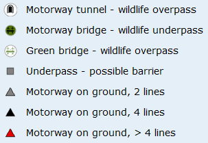
Barrier analysis - motorway intersections
Motorway barrier intersection
Represents intersections between the regional potential linkages and different categories of motorway infrastructures ( Motorways, Motorway tunnels, motorway bridges, green bridges, underpasses).
Legend:
Motorway level
Legend:
Selected Strategical Alpine Connectivity Areas (SACAs)
Ecological Conservation Areas (SACA1) > 300ha
Ecological Conservation Areas (SACA1) with a surface larger than 300 hectares.
Legend:Stepping stones (SACA 1) < 300ha
Ecological Conservation Areas (SACA1) with a surface smaller than 300 hectares.
Legend:Connectivity Restoration Areas (SACA3)
Connectivity restoration areas (SACA3) represent important barriers between SACA1 areas (ecological conservation areas).
Legend:Access to underlying data / download section
Download the PDF
You can download the detailed report on the mapping process (PDF).
Link to underlying data
You can download the datasets resulting from this project from this external website.
Link to underlying data
You can download the datasets resulting from this project from this external website.
Link to underlying data
You can download the datasets resulting from this project from this external website.